Look a little closer
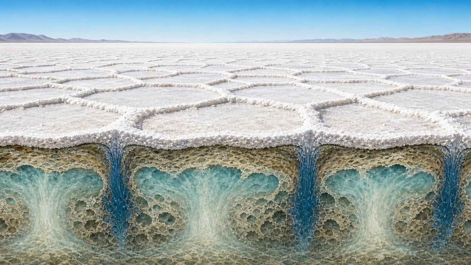
The honeycomb-like polygons on many salt flats are not produced only by a crust drying and cracking. They grow above circulating brine in the wet porous sediment below. Evaporation makes near-surface water unusually salty and dense; that brine sinks beneath polygon boundaries while less salty water rises beneath the interiors. The sinking boundaries receive a larger salt supply, so repeated crystallization raises the bright ridges that reveal an otherwise invisible flow pattern.
Salt flats commonly occupy arid basins with little external drainage. Rain and streams dissolve ions from surrounding rocks and carry them into a low area. When a shallow lake or groundwater evaporates, water escapes to the atmosphere while dissolved salts remain. A surface that looks dry can still overlie sand and silt whose pores contain brine. That saturated porous layer provides the space in which the pattern-forming circulation operates.
Dry air and sunlight continually remove water near the surface. Capillary action draws groundwater upward to replace it, and evaporation concentrates the dissolved salt in the remaining liquid. Salty water is denser than fresher water at the same temperature. The process therefore builds an unstable arrangement: relatively heavy brine lies above less saline, lighter fluid. Gravity can release that instability even though the water must squeeze between sediment grains.
Dense brine begins to descend in narrow fingers or sheets, while broader regions of less salty water rise to replace it. The motion resembles convection in a heated pot, but the density contrast comes mainly from salinity rather than temperature, and the sediment strongly resists the flow. Physicists call this buoyancy-driven convection in a porous medium. Once established, adjacent circulation cells organize where water rises and where it returns downward.
A group of similar cells must divide the available surface without gaps. Their downwelling zones meet in a connected network, and nearly circular territories deform into straighter shared boundaries. Three boundaries often meet at a junction, producing a tiled field of polygons. Hexagons are common because comparable regions can pack efficiently into a honeycomb-like network, but real salt flats are not perfect geometry exercises. Five-, six-, and seven-sided cells can coexist, and their edges curve or terminate.
The ridges make the underground boundaries visible. In the model developed by researchers, circulation delivers a greater upward salt flux to the surface above the narrow downwellings, where subsurface salinity gradients are weaker. Crystals preferentially accumulate there. Small relief differences can then influence surface moisture and offer sites for further deposition. Wetting and drying episodes repeatedly add salt along persistent boundaries, turning a subtle chemical contrast into a raised white line.
This explanation combines more than a visually convincing simulation. Researchers used terrestrial laser scanning to measure surface relief at California's Owens Lake and Badwater Basin, sampled salinity and pore-water density across ridges, and characterized the underlying grains. They compared those observations with laboratory analogues and numerical models. The same convection framework reproduced the locations and spacing of downwellings and explained the characteristic scale—often roughly one to two meters at the studied pans—without setting each polygon by hand.
Not every polygonal landscape has this origin. Ordinary mud contracts as it dries and forms tensile cracks; freeze-thaw processes and biological patterning can create other networks. A salt crust can also contain shallow shrinkage cracks alongside its raised ridges. The convection account is most relevant where persistent evaporation, subsurface brine, permeable sediment, measured salinity structure, and salt-built relief occur together. Shape alone is not enough to diagnose the mechanism.
Polygon size and clarity vary because the operating conditions vary. Evaporation rate, groundwater depth, grain size, permeability, salinity contrast, and the history of flooding and drying all influence whether circulation starts and remains organized. Vehicle tracks or mining can interrupt the surface network. A satellite image therefore captures a changing state, not an ornamental crust frozen outside time.
The principal pattern maker is ultimately the slow brine circulation beneath the visible crystals. Evaporation creates a density inversion, the inversion drives porous convection, and focused salt transport along cell boundaries builds ridges. That chain explains why distant salt deserts can repeat similar polygon scales. It also means the ridges are useful surface evidence of how groundwater, salt, and potentially windblown dust are being redistributed across a dry basin.
EDITORIAL RESPONSIBILITY
FactosBrain Editorial Desk
The FactosBrain Editorial Desk researched and reviewed this article under our editorial policy. We assess error reports under our corrections policy.